Camdeboo

The vast plains of the Camdeboo stretch from the foothills of the Sneeuberge, or Snow Mountains, in the north to the rugged wilderness of the Baviaans Mountains in the south. The Camdeboo also transitions from the tinder-dry Koup Karoo in the west to the gentler landscape of the Eastern Karoo and ultimately the lush rolling hills of Settler Country and the old Transkei in the east.
The vast plains dwarf the tiny Karoo towns of Aberdeen and Pearston, giving way in the south to the Noorsveld along the northern littoral of the Baviaans Mountains where the historic villages of Jansenville, Klipplaat, Mount Stewart and Steytlerville stand sentinel on the southern fringe of the great plains of the Camdeboo.

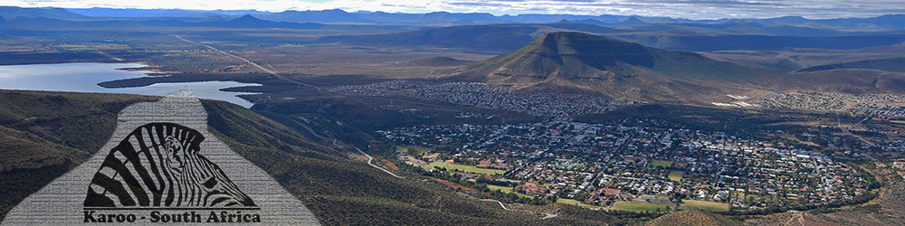
Central to the Camdeboo is the historic town of Graaff-Reinet, almost entirely surrounded by the Camdeboo National Park and dominated by the great bulk of Spandau Kop, which stands proud above the great horseshoe sweep of the Sundays River below Nqweba Dam.
The Camdeboo is one of the most beautiful and atmospheric regions of the Great Karoo. The sweeping plains and rugged mountains rise from an elevation of approximately 700-metres above sea level on the plains south of Graaff-Reinet, as high as the 2,502-metre high Kompasberg, or Compass Mountain, the highest mountain peak in the district that looms to the north over the isolated village of Nieu Bethesda that is cradled in a fertile valley surrounded by the Voor-Sneeuberge to the south and the Rooiberg, or Red Mountain, to the west.
The edge of the escarpment rising above the great plain of the Camdeboo revels in a variety of names including the Camdeboo Mountains in the west and moving towards the east includes Toorberg, or the Bewitched Mountain; Suurberg, or Sour Mountain; Goewermentskop, or Government’s Mountain directly north of Graaff-Reinet and to the east Tandjiesberg, or Teeth Mountain; Aasvoelberg, or Vulture Mountain, Bouwershoekberge, Coetzeesberge and Groot Bruintjieshoogte north-east of Pearston.


This great ring of mountains marks the transition from the immense flat plain of the Camdeboo in the south to the great escarpment and mountains to the north of the Camdeboo region.

At the southern end of the Camdeboo Plain the Grootrivierberge, or Great River Mountains, in the west and the Klein Winterhoekberge, or Small Winter Hook Mountains, in the east are spread out to the south of Jansenville, Mount Stewart and Klipplaat.


Further south the isolated villages of Willowmore and Steylerville are pleasantly situated to the north of the Baviaansberge, one of the most remote and beautiful mountain wilderness areas on the southern fringes of the Great Karoo.

Eve Palmer in her book The Plains of Camdeboo describes the Camdeboo as "a country flooded by sun, lonely, sparse, wind-swept and treeless on the flats for many miles." Rainfall varies from 300-milimetres in a good year to less than 75-milimetres per annum in a bad year and therefore the existence of the farmers and stock men spread out across this great plain is at best precarious.
The principle agricultural activity in the district is stock farming with merino and dorper sheep and the distinctive angora goat providing the backbone of commercial farming activity. The mohair industry is well-developed and the village of Jansenville is regarded as the epicentre of a vast swathe of Karoo where the farming of angora goats predominates.
The name Camdeboo derives from the Khoikhoi and means either green heights or green hollow deriving from the existence of water in the mountains and valleys that provided a splash of green in the otherwise arid landscape. In common with other areas in the Karoo the Camdeboo is a melting pot of both indigenous and European cultures with a rich heritage of influences from the Khoi, Xhosa, Trek Boers or nomadic farmers of primarily Dutch and French descent and British settlers.


Horseshoe Bend in the Sundays River
Graaff-Reinet, the principle town of the Camdeboo, is the fourth oldest town in South Africa dating from 1786 and boasts more than 220 national monuments reflective of a rich and varied history.
The Camdeboo invites exploration and the network of country roads and the isolated towns and villages scattered across the great plain and in the surrounding mountains provide an endless source of interesting scenic, cultural and historic experiences that will entice the visitor to stay longer in order to get a true sense of this extraordinary region of the Great Karoo. The laid-back pace of life, the almost endless sunshine and the extraordinary vistas of rolling mountains and sweeping plains are the backdrop to one of the most enticing areas in South Africa. All that is needed is a sense of adventure, the lure of the open road and the time to explore.