
Beaufort West

Explore
Beaufort West lies at the crossroads of the Great Karoo. Distances are vast and the closest towns and villages are all more than 100-kilometres distant. Beaufort West is an excellent base to explore the spectacular Karoo National Park, with its entrance gate situated approximately five kilometres from the town-centre on the N1 highway towards Laingsburg. For the very first time in more than a century the Nuweveld Mountains echo to the roar of wild lions recently re-introduced to the Park. The Karoo National Park is also an important sanctuary for the critically endangered Riverine Rabbit.

Just beyond the turnoff to the Karoo National Park the traveller reaches the N12 turnoff from the N1 highway towards Oudtshoorn and the Klein Karoo. The N12 stretches across the undulating landscape of the Koup with the high ramparts of the Swartberg Mountains looming in the distance.
Approximately 78-kilometres from the N1 junction the N12 highway reaches a crossroad linking the tiny Karoo village of Rietbron and the hamlet of Seekoegat. Seven kilometres south of this junction a gravel road branches off the N12 highway towards Prince Albert passing through a narrow defile in the Tierberg and finally, flanking the northern slopes of the Ou Kloof Mountains, enters Prince Albert.
Beyond this junction the N12 highway approaches the Swartberg Mountains passing the tarred R407 turnoff west to Prince Albert and further on the tiny village of Klaarstroom. From Klaarstroom the gravel R407 leads east following the scenic northern slopes of the Swartberg Mountains for a distance of 95-kilometres to Willowmore in the Eastern Cape.
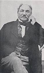
Beyond Klaarstroom the N12 approaches a narrow defile through the Swartberg Mountains following the course of the Groot or Big River. Before the construction of Meiringspoort there were no roads linking the Great Karoo and the Klein Karoo. In 1854 the renowned road engineers Andrew Geddes Bain and his son Thomas Bain together with the irrepressible Sir John Molteno, Member of Parliament for Beaufort West, surveyed the great "kloof" or defile through the Swartberg Mountains through which Meiringspoort would be constructed.

The road was ultimately surveyed by a number of eminent road engineers including Andrew Geddes Bain and Thomas Bain and the 16-kilometre Pass was constructed in 223 work days, crossing the Groot River 21 times at a cost of £5,018, just £18 above the allocated budget of £5,000. The engineers had initially requested £50,000 in order to construct a properly engineered road. However, this was considered unaffordable at the time. Unfortunately the sub-standard road was highly susceptible to flooding as it was constructed in very close proximity to the river bed of the Groot River. In 1859, 1861 and 1875 the road was closed for long periods due to flooding and a massive flood in 1885 washed almost every vestige of the road away.

Over the years the road was rebuilt and improved after repeated flooding. However, it was only after a major flood in 1996 that the reconstruction of Meiringspoort was begun, resulting in a spectacular road that sweeps through the narrow mountain "poort" with many opportunities to stop and admire the awe-inspiring scenery and the sheer twisted ramparts of rock that tower above the road.

The rebuilt road through Meiringspoort was opened in 2000. Approximately halfway through the "poort" there is an information centre. From this facility a narrow footpath leads around a sheer fold in the mountain to a deep rock pool and cascade of water fed by a high waterfall that sweeps over a lip of rock that frames the blue sky above.

Beyond Meiringspoort the N12 highway reaches the small Klein Karoo town of De Rust and the junction with the tarred R341 road that leads east through the Kamanassie Valley towards Uniondale and Willowmore.
Beyond De Rust the N12 highway traverses the southern slopes of the Swartberg Mountains towards Oudtshoorn, the principle town of the Klein Karoo, a further 35-kilometres distant.
Beyond the N12 junction, the N1 highway continues for almost 200-kilometres across the undulating landscape of the Koup. The road passes the tiny hamlet of Leeu Gamka, 75-kilometres from Beaufort West from where the tarred R353 leads for 110-kilometres via the spectacular Teekloof Mountain Pass to the isolated village of Fraserburg situated high above the Nuweveld Mountains escarpment.
Beyond Leeu Gamka the N1 highway reaches a gravel road junction to Prince Albert and 40-kilometres from Leeu Gamka reaches the tiny hamlet of Prince Albert Road and a crossroads leading along the tarred R407 to Prince Albert and in the opposite direction along the gravel road to Merweville. A further 84-kilometres beyond Prince Albert Road along the N1 highway the road leads into Laingsburg.

A wonderful atmospheric gravel loop road links Beaufort West, Fraserburg and Loxton returning to Beaufort West via the Molteno Mountain Pass. This loop road is more than 300-kilometres in length and requires a full day to enjoy at leisure.
From Beaufort West proceed along the N1 highway towards Laingsburg turning towards Fraserburg along the gravel road a few kilometres beyond the N12 junction to Oudtshoorn. The gravel road proceeds across the Koup with long views to the north and east of the quintessential Karoo mountain range of the Nuweveld Mountains.
The gravel road reaches a junction to Fraserburg via the Nuweveldberge traversing the Oukloof Mountain Pass. From this junction the road continues towards Merweville. Turning towards Fraserburg the road follows the usually dry Koekemoers River bed past the 1,655-metre high Kraaifontein Mountain. The road leads up the Oukloof Mountain Pass onto the high central Plateau and into the village of Fraserburg, an ideal spot for a relaxing lunch or a late morning cup of coffee.

From Fraserburg the R356 snakes across the high escarpment passing a number of isolated farms to the atmospheric village of Loxton where there are a number of options to enjoy a relaxed lunch.
The return road to Beaufort West is one of the most beautiful of the Great Karoo with sweeping vistas in all directions and beautiful old farms shaded by poplar and plain trees. The road makes a spectacular descent of the Nuweveld Mountains via the Molteno Pass to Beaufort West.
From Beaufort West the N1 highway continues north-east towards Three Sisters where the N12 branches north towards Victoria West and Kimberley.

The N1 continues further north-east gradually ascending the high escarpment towards the village of Richmond some 183-kilometres from Beaufort West.
Forty kilometres along the N1 highway from Beaufort West the road reaches a turnoff towards Nelspoort famous for its tuberculosis sanatorium and the rock engravings of the long-disappeared Xam people.
The historical shelter in Tierkloof is probably the best preserved site of these type of engravings in the Great Karoo. One of the engravings features a bovine creature thought to be Megalotragus, which has been extinct for more than 10,000 years.

From Nelspoort a gravel road branches south skirting the western slopes of "Blinkfontein se Berg" or Bright Fountains Mountain and Pienaars Ridge towards Aberdeen on the distant plains of the Camdeboo.
Another gravel road leads east past Klein Waaifontein Mountain towards Murraysburg in the foothills of the Sneeuberge or Snow Mountains.
The R61 stretches east across an almost featureless plain, known locally as "Die Vlaktes" or The Flats, for more than 140-kilometres from Beaufort West to Aberdeen and beyond to Graaff Reinet.
As one travels east the bulk of the Nuweveld Mountains recedes into the flat plain as the jagged peaks of the Camdeboo Mountains and the
1,777-metre high Sleeping Giant rise up out of the featureless plain as a lonely sentinel welcoming the traveller to the Camdeboo. Nineteen kilometres outside Beaufort West the gravel R306 branches off the R61 towards the tiny village of Rietbron situated in the middle of "Die Vlaktes" and beyond to Willowmore, the southern gateway to the Plains of the Camdeboo and the western gateway to the spectacular Baviaanskloof Mountain Pass.